Using the whitebox_tools.py script
Interacting with WhiteboxTools from Python scripts is easy. To begin, each script must start by importing the WhiteboxTools class, contained with the whitebox_tools.py script; a new WhiteboxTools object can then be created:
from WBT.whitebox_tools import WhiteboxTools

wbt = WhiteboxTools()
Depending on the relative location of the WhiteboxTools directory and the script file that you are importing to, the import statement may need to be altered slightly. In the above script, it is assumed that the folder containing the WhiteboxTools files (including the whitebox_tools Python script) is named WBT (Line 1) and that the calling script that is importing WhiteboxTools is located in the parent directory of WBT. See An Example WhiteboxTools Python Project for more details on project set-up. The use of wbt to designate the WhiteboxTools object variable in the above script (Line 3) is just the convention used in this manual and other project resources. In fact, any variable name can be used for this purpose.
The WhiteboxTools class expects to find the WhiteboxTools executable file (whitebox_tools.exe on Windows and whitebox_tools on other platforms) within the same directory (WBT) as the whitebox_tools.py script. If the binary file is located in a separate directory, you will need to set the executable directory as follows:
wbt.set_whitebox_dir('/local/path/to/whitebox/binary/')
Individual tools can be called using the convenience methods provided in the WhiteboxTools class:
# This line performs a 5 x 5 mean filter on 'inFile.tif':
wbt.mean_filter('/file/path/inFile.tif', '/file/path/outFile.tif', 5, 5)
Each tool has a cooresponding convenience method. The listing of tools in this manual includes information about each tool's Python convienience method, including default parameter values. Parameters with default values may be optionally left off of function calls. In addition to the convenience methods, tools can be called using the run_tool() method, specifying the tool name and a list of tool arguments.
source = "source.tif"
cost = "cost.tif"
out_accum = "accum.tif"
out_backlink = "backlink.tif"
args = []
args.append("--source='{}'".format(source))
args.append("--cost='{}'".format(cost))
args.append("--out_accum='{}'".format(out_accum))
args.append("--out_backlink='{}'".format(out_backlink))
self.run_tool('cost_distance', args)
Each of the tool-specific convenience methods collect their parameters into a properly formated list and then ultimately call the run_tools() method. Notice that while internally whitebox_tools.exe uses CamelCase (e.g. MeanFilter) to denote tool names, the Python interface of whitebox_tools.py uses snake_case (e.g. mean_filter), according to Python style conventions. The only exceptions are tools with names that clash with Python keywords (e.g. And(), Not(), and Or()).
The return value can be used to check for errors during operation:
if wbt.ruggedness_index('/path/DEM.tif', '/path/ruggedness.tif') != 0:
    # Non-zero returns indicate an error.
    print('ERROR running ruggedness_index')
If your data files tend to be burried deeply in layers of sub-directories, specifying complete file names as input parameters can be tedius. In this case, the best option is setting the working directory before calling tools:
from whitebox_tools import WhiteboxTools

wbt = WhiteboxTools()
wbt.set_working_dir("/path/to/data/") # Sets the working directory

# Setting the following to True enables tools to output DEFLATE compressed GeoTIFFs.
# You only need to do this once, if you wish all tools to compress their raster
# outputs.
wbt.set_compress_rasters(True)

# Because the working directory has been set, file arguments can be
# specified simply using file names, without paths.
wbt.d_inf_flow_accumulation("DEM.tif", "output.tif", log=True)
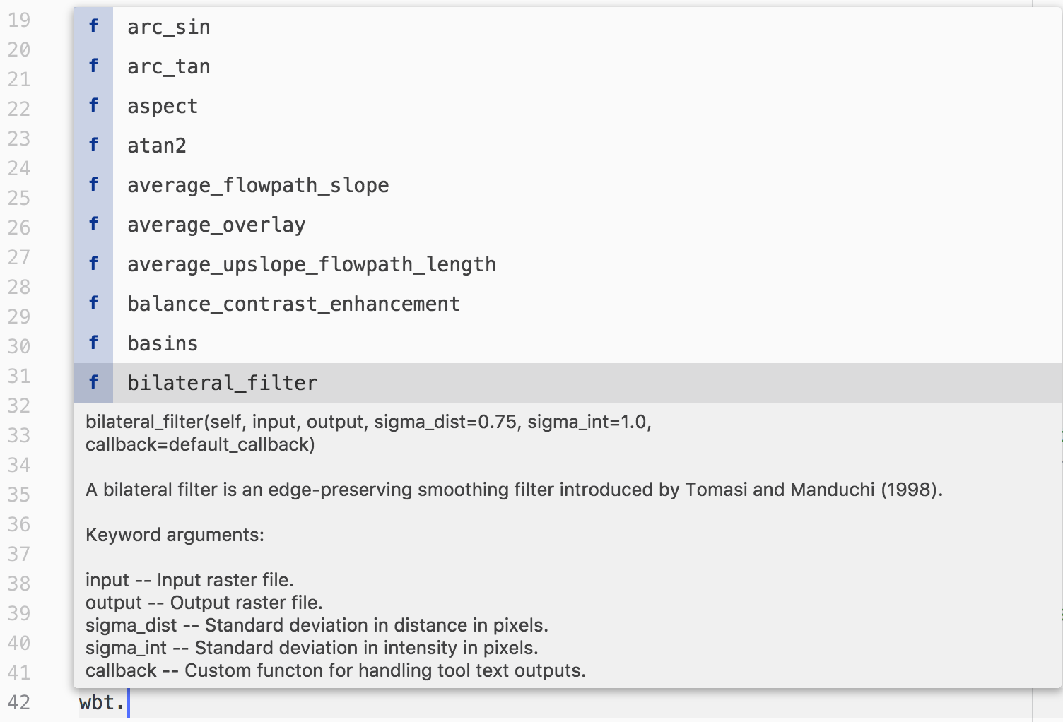
An advanced text editor, such as VS Code or Atom, can provide hints and autocompletion for available tool convenience methods and their parameters, including default values (Figure 1).
Sometimes it can be useful to print a complete list of available tools:
print(wbt.list_tools()) # List all tools in WhiteboxTools
The list_tools() method also takes an optional keywords list to search for tools:
# Lists tools with 'lidar' or 'LAS' in tool name or description.
print(wbt.list_tools(['lidar', 'LAS']))
To retrieve more detailed information for a specific tool, use the tool_help() method:
print(wbt.tool_help("elev_percentile"))
tool_help() prints tool details including a description, tool parameters (and their flags), and example usage at the command line prompt. The above statement prints this report:
ElevPercentile
Description:
Calculates the elevation percentile raster from a DEM.
Toolbox: Geomorphometric Analysis
Parameters:

Flag               Description
-----------------  -----------
-i, --input, --dem Input raster DEM file.
-o, --output       Output raster file.
--filterx          Size of the filter kernel in the x-direction.
--filtery          Size of the filter kernel in the y-direction.
--sig_digits       Number of significant digits.

Example usage:
>>./whitebox_tools -r=ElevPercentile -v --wd="/path/to/data/" --dem=DEM.tif
>>-o=output.tif --filterx=25
A note on default parameter values
Each tool contains one or more parameters with default values. These will always be listed after any input parameters that do not have default values. You do not need to specify a parameter with a default value if you accept the default. That is, unless you intend to specify an input value different from the default, you may leave these parameters off of the function call. However, be mindful of the fact that Python assigns values to parameters based on order, unless parameter names are specified.
Consider the Hillshade tool as an example. The User Manual gives the following function definition for the tool:
hillshade(
dem,
output,
azimuth=315.0,
altitude=30.0,
zfactor=1.0,
callback=default_callback)
The
demandoutputparameters do not have default values and must be specified every time you call this function. Each of the remaining parameters have default values and can, optionally, be left off of calls to thehillshadefunction. As an example, say I want to accept the default values for all the parameters exceptaltitude. I would then need to use the named-parameter form of the function call:wbt.hillshade( "DEM.tif", "hillshade.tif", altitude=20.0)If I hadn't specified the parameter name for
altitude, Python would have assumed that the value 20.0 should be assigned to the third parameter,azimuth.