
This release does not include very many new tools. Despite this, this is probably one of the largest releases yet. We have made extensive changes to the codebase, improving functionality in many significant ways. Therefore, we’re very excited to announce the release of v1.5.
Probably the most exciting change is the introduction of plugin tools. Up until now, WBT has had a monolithic architecture, where all of the tools live within a single binary. This architecture has provided a number of benefits up until now. However, as the number of tools in WBT grows, it becomes increasingly difficult to maintain this program structure – in particular, compile times have grown significantly since the projects start. A plugin architecture provides much greater flexibility in this regard. Single tool plugins can be created, placed within the new ‘plugins’ folder within the WBT directory, and the whitebox_tools.exe binary will treat these plugins like any other tool within the monolith. This also means that WBT users can develop their own custom tools, without the required know-how of figuring out how to integrate their tool into the large WBT code-base. The user manual will be updated shortly to describe how this process works. For now, there is only one plugin tool example in the open-core (SplitVectorLines) although several other plugins have been developed (more on this below). The one downside of the new plugin architecture is that the size of the WBT download will inevitably grow, as individual tool executables will be larger than the single monolith. We believe that this is an acceptable compromise.
In order to accommodate plugin tools, we have significantly changed the codebase. Most significantly We have pulled the code associated with low-level functions, the so-called ‘plumbing’ code, (e.g. code for reading and writing various data files) into separate sub-repositories. In this way, the tools in the monolith and the plugin tools can both use this code without duplication. WBT now has persistent environment variables contained within a ‘settings.json‘ file within the WBT folder. Currently, these settings including ‘verbose_mode’, ‘working_directory‘, ‘compress_rasters‘, and ‘max_procs‘. More environment variables may be added in later releases. The fact that verbose mode the working directory, and the compress_rasters flag are now persistent does have implications for the Python and R front-ends and for the way these settings are used. The user manual will be updated shortly to reflect these changes.
We introduced the ‘max_procs‘ setting. Now, all tools that run in parallel, or partially parallelize, can be restricted to a maximum number of processes. Before, WBT would simply use all of the available cores in the machine it was running on. While this is still the default (`max_procs: -1`), there are certain conditions where this behaviour is undesirable. For example, when WBT is run on large servers or cloud-computing environments where a great many cores are shared among many users, it can be problematic when a single user/program consumes all of the available cores. This setting limits the maximum number of procs.
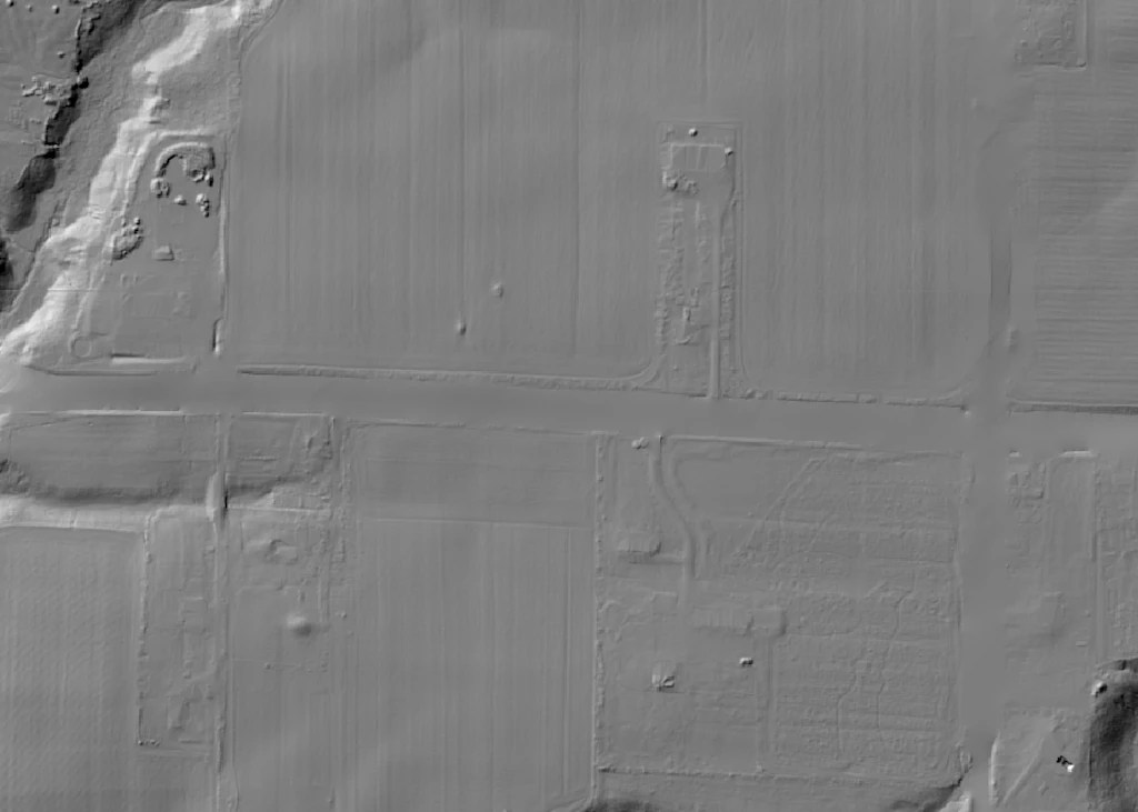
This new version adds two new tools as well, including the EmbankmentMapping and SplitVectorLines tools. The EmbankmentMapping tool can be used for mapping transportation embankments (road, rail) in LiDAR DEMs. See image down below for example of how this tool works. The SplitVectorLines tool, will parse an input line vector into a series of segments of a specified length, It is also an example of a WBT plugin.
The code has been updated to reflect the new zLidar v1.1 specification, which has significantly improved compression rates (testing shows it is between 91% and 109% of LAZ), greater flexibility (users may specify the degree of compression versus speed of reading/writing), and numerous bug fixes. The zLidar specification webpage will soon be updated to reflect the new version. Further news on this front, it has come to our attention recently that there is now a Rust-based LAZ encoder/decoder, which provides an opportunity for us to add LAZ support in a future version of WBT. We are currently evaluating this as an option.